From field data to operational clarity
Current professional work across DIMP/TIMP, pipeline integrity analysis, dashboards, Survey123, Experience Builder, and infrastructure data quality.
From infrastructure practice to environmental research and urban planning. Find a topic, explore the method, and see the original work.
58 projects · 11 detailed case studies
The question, the approach, and the outcome.
Current professional work across DIMP/TIMP, pipeline integrity analysis, dashboards, Survey123, Experience Builder, and infrastructure data quality.
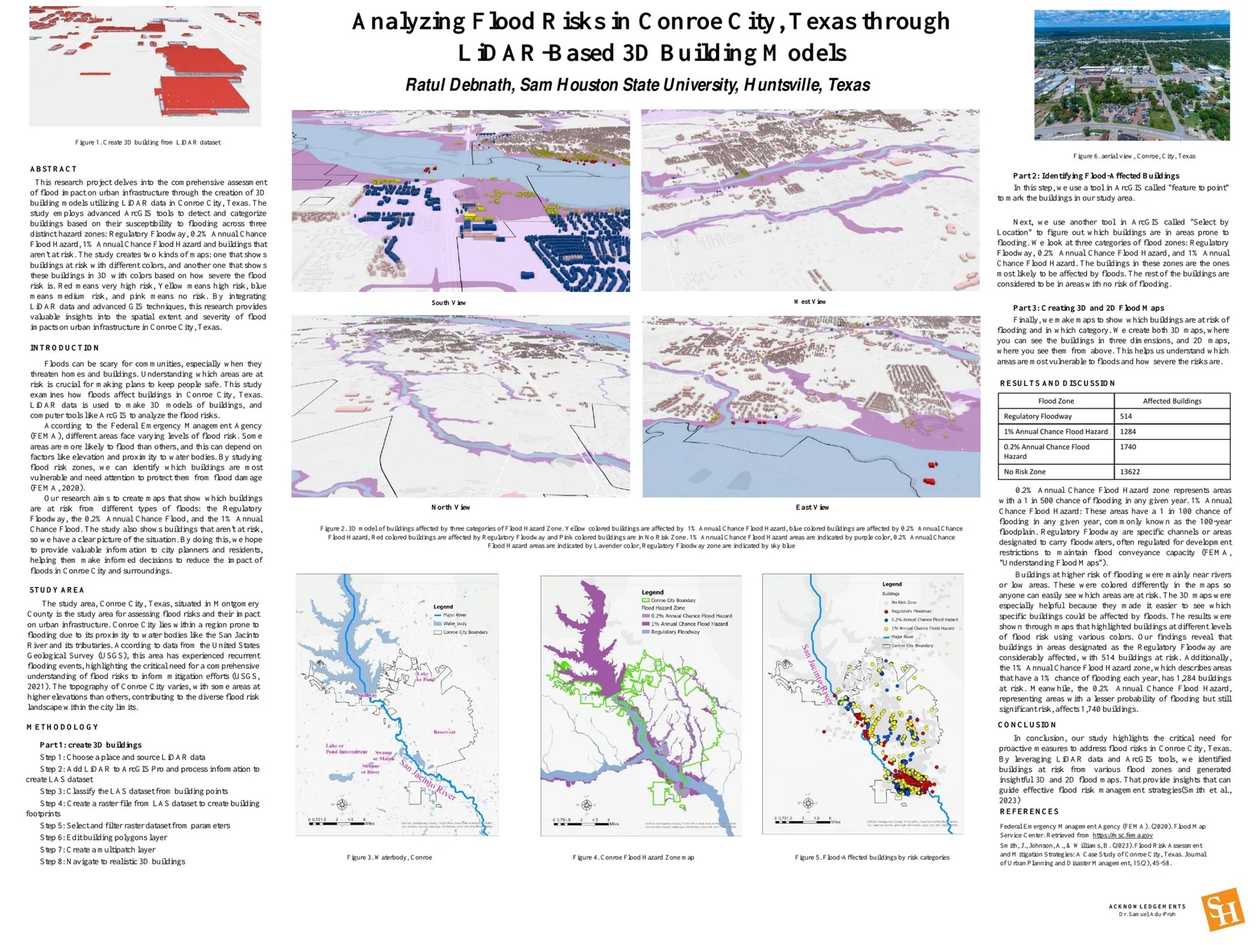
Combining LiDAR-derived buildings and mapped flood zones to make structural exposure visible.
Using network analysis to evaluate sheltered bus-stop locations and population coverage.
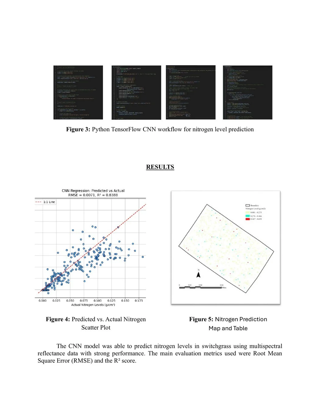
Connecting UAV imagery, field observations, and a convolutional neural network to estimate switchgrass nitrogen content.
A GIS-based Walkable Service Area Analysis model across 64 census tracts.
Weighted overlay and spatial statistics connecting hydrography, land cover, and population.
A LiDAR vegetation study mapping canopy intensity across 173.28 square kilometers.
A published study combining LiDAR and multispectral signatures for flood-hazard mapping.
A GIS-based framework connecting environmental overlays, consequence indicators, and risk review.
A planning review of downtown development, public space, historic preservation, transportation, and housing challenges.
A map-based comparison of reported crime patterns, time periods, and neighborhood context.
Bachelor of Urban & Regional Planning
Khulna University of Engineering & Technology
10 thesis, studio, survey, and internship contributions
Early work across housing, public space, environmental planning, community participation, and municipal GIS. These projects connect site-based observation with the needs of people and places.
Khulna University of Engineering & Technology · Khulna, Bangladesh
Studied rooftop gardening in Sonadanga Residential Area, Khulna City, examining its potential as an urban green-space strategy and a source of household food. The thesis connected residential planning with sustainable use of underused rooftop space.
Khulna University of Engineering & Technology · Khulna, Bangladesh
Conducted social and physical surveys to profile neighborhood conditions in Sheikhpara. The study examined socio-economic characteristics alongside the local physical environment to inform an understanding of planning needs.
Khulna University of Engineering & Technology · Khulna, Bangladesh
Developed landscape and safety-improvement proposals for the Natun Rastar Mour intersection in Daulatpur, Khulna. Site analysis and visual planning tools supported the design concept.
Khulna University of Engineering & Technology · Khulna, Bangladesh
Prepared a site and area-development plan for a proposed residential neighborhood in Harintana. The plan considered land-use allocation, accessibility, and infrastructure layouts as connected elements of neighborhood design.
Khulna University of Engineering & Technology · Khulna, Bangladesh
Proposed a mass-housing and service-upgrade concept for the Jora Gate Bazar settlement. The project emphasized participatory design and integration with the surrounding city.
Khulna University of Engineering & Technology · Khulna, Bangladesh
Examined livelihood and socio-economic changes associated with displacement and resettlement around the Padma Bridge project. Surveys and GIS mapping supported the assessment of infrastructure-related community impacts.
Khulna University of Engineering & Technology · Khulna, Bangladesh
Used participatory mapping, focus group discussions, and stakeholder interviews to identify local urban problems. The work translated community perspectives into suggestions for locally informed planning responses.
GIZ project survey contribution · Bangladesh
Contributed survey work to GIZ’s UMIMCC project, supporting understanding of climate-related internal migration and urban living conditions. The assignment formed part of my early field experience in environmental and community planning.
Field survey and GIS assignment · Khulna, Bangladesh
Worked as a surveyor and GIS analyst on a study of the Mayur River and connected canals. Field data collection, GPS mapping, and spatial analysis supported urban environmental planning for the river system.
Khulna City Corporation · Khulna, Bangladesh
Prepared and analyzed ward maps using ArcGIS during an internship with Khulna City Corporation. The placement connected classroom GIS training with municipal mapping practice.
Professional work, university research, graduate planning studies, and GIS training.
Maintain pipeline and service-line datasets, reconcile work orders with mapped mains, and connect assets to the documents that support them.
Prepare spatial integrity analyses and maintain segment-level risk inputs, connecting pipeline data with environmental and consequence information.
Contribute GIS models, verified pipeline and inspection records, and risk documentation to distribution and transmission integrity management.
Date-based status lifecycle, document attachments, coordinated filters, and mapped review.
Barcode lookup for pipeline attributes, with a photo-based fallback and collection guidance.
Cascading selections, requested-area geometry, sensor choices, date ranges, and supporting files.
Professional Associates Ltd. · Bangladesh · 2017–2019
Contributed GIS and planning support at Professional Associates Ltd. for a proposed national border-belt road study. Work included road-alignment support, land-use analysis, and environmental assessment.
Professional Associates Ltd. · Dhaka, Bangladesh · 2017–2019
Supported a proposed urban corridor plan in Dhaka at Professional Associates Ltd. Contributions addressed traffic-flow improvement, zoning recommendations, and spatial visualization for infrastructure coordination.
Interactive indicators, charts, and flight connections for Minneapolis–St. Paul International Airport.
A training dashboard combining stream gauges, weather, pump stations, and floodwall information.
Map layers, bookmarks, swipe comparisons, and an attribute table for Hunter Wetlands National Park.
A multipage Experience Builder exercise with event lists, map views, and responsive navigation.
Research on a consistent workflow for collecting and preparing drone imagery.
Terrain and surface indicators across 210 analysis zones for erosion and flood-susceptibility interpretation.
Alabama A&M University · Madison County, Alabama
Developed and calibrated trip-generation models using household travel survey data and land-use characteristics to support regional travel-demand estimation. This graduate research was also presented at the 2020 Alabama–Mississippi APA Joint Virtual Conference.
Alabama A&M University · Birmingham, Alabama
Participated in a graduate planning studio focused on pedestrian access and the aesthetic quality of urban corridors. The design work combined streetscape principles, cultural context, and multimodal access.
Alabama A&M University · Huntsville, Alabama
Contributed to a graduate team project on neighborhood traffic management and pedestrian planning for a livable, walkable city. The team project was presented at the NAAAS Conference in 2020.
Alabama A&M University · Alabama
Investigated automobile-dependency trends using demographic and transportation datasets. The graduate project examined challenges for sustainable mobility and considered policy responses.
Sam Houston State University
Compared crime patterns in two cities using hotspot and spatial-temporal analysis. The academic study considered differences in urban safety patterns across their distinct geographic settings.
University of Hawaiʻi at Mānoa · NDPTC
Coordinated observational site surveys across Hawaiʻi, collecting information on seatbelt, child-restraint, helmet, and truck-bed use. This work supported transportation-safety research at the National Disaster Preparedness Training Center.
ArcGIS coursework exploring spatial assessment of hospital distribution in texas. Original work is documented in the academic assignments collection.
ArcGIS coursework exploring groundwater salinity classification for azraq basin, jordan. Original work is documented in the academic assignments collection.
ArcGIS coursework exploring coordinate systems and projections. Original work is documented in the academic assignments collection.
ArcGIS coursework exploring introduction to the geodatabase. Original work is documented in the academic assignments collection.
ArcGIS coursework exploring data editing and topology. Original work is documented in the academic assignments collection.
ArcGIS coursework exploring geoprocessing. Original work is documented in the academic assignments collection.
ArcGIS coursework exploring site suitability and data modeling. Original work is documented in the academic assignments collection.
ArcGIS coursework exploring geocoding. Original work is documented in the academic assignments collection.
ArcGIS coursework exploring rasters. Original work is documented in the academic assignments collection.
ArcGIS coursework exploring spatial interpolation. Original work is documented in the academic assignments collection.
ArcGIS coursework exploring watershed delineation. Original work is documented in the academic assignments collection.
ArcGIS coursework exploring geostatistical analysis. Original work is documented in the academic assignments collection.
ArcGIS coursework exploring proximity and network analysis. Original work is documented in the academic assignments collection.
ArcGIS coursework exploring tin and arcgis online. Original work is documented in the academic assignments collection.
University of Hawaiʻi at Mānoa · NDPTC · 2021–2022
Contributed to an observational study of homelessness in Waikīkī using computer vision and machine-learning methods during my research assistant appointment at the National Disaster Preparedness Training Center.
University of Hawaiʻi at Mānoa · NDPTC · 2021–2022
Used computer vision and machine-learning methods for seatbelt-use observation as part of transportation-safety research at the National Disaster Preparedness Training Center.
DevConsultants Limited · Bangladesh
Supervised surveys of vehicle speed, seatbelt and helmet use, and pedestrian crossing behavior at DevConsultants Limited. The assignment supported a road-safety hazard and intersection-countermeasure study on national and regional highways.
Try a broader topic, choose another focus area, or clear the filters.
Working on a spatial challenge, exploring a professional opportunity, or bringing a research idea to life? I’d welcome the connection.
The Woodlands, Texas
A little context helps make the connection meaningful.